
1. What is this pattern?

2. What is this pattern?
3. What is "Area X," the lighter green area? How about "Area Y," the brown area?

4. This is your basic _____________ map of _______________. 
5. And this map shows the distribution of ____________.
Submit your answers in the comments.
Coming Soon: Those of you who get off on this kind of thing -- and you know I do -- should be sure to check in for next weekend's post, where we'll be doing a special Master's Quiz on American Mapscapes! It will be heaps harder.

24 comments:
1. Population
2. Rainfall
3. X=Louisiana Purchase
Y=Glasden (sp?) Purchase
4. Topographic-Bum**** Egypt
5. Mormons per square mile?
1. population density
2. amount of rainfall
3. X -- Louisiana Purchase, Y -- ?
4. ...your basic pretty map of colors
5. something by counties...number of polygyny families per county?
A Carto-quiz! I should ace this... but... maybe not...
1. Population Density?
2. Altitude above sea level?
3. x=Louisiana Purchase, y=Gadsden Purchase
4. This is your basic multi-colored map of Pennsylvania! (again, it looks like altitude or topography or something like that.)
5. Distribution of Mormons (from the Pew Report!)
1. Population density by county
2. Annual Rainfall
3. X = Looezeana Purchase (these days a Louisiana purchase refers to a fifth of 151 rum and a gun). Y = Radioactivity Cession of 1945.
4. Average temperatures of Pennsylvania
5. Mormon population by county
1 population density
2 rainfall totals
3 area x = land gained in the louisiana purchase; area y = land gained after mexican/american war?
4 this is your basic satellite map of cloud flow/weather/snowfall
5 mormons
1. Um, People over 65??
2. Rainfall
3. x = Louisiana Purchase
y = Oh god, I can't remember its name. Galston? Acquisition.
4. Elevation, Pennsylvania
5. Wolves?
Everyone else is saying Mormon. I said wolves. I'm sorry, I didn't mean to offend any of you LDS's out there. I'm sure you're not wolfish as all.
1. population
2. rainfall
3. Louisiana Purchase, Arizona "Returned Because It Didn't Fit Just Right"
4. USDA map of plant hardiness zones
5. Mormons, I guess, though that seems to obvious for #5 on the list.
1. Population density
2. Average rainfall
3. X = Louisiana Purchase; Y = Gadsen Purchase (cost the same, didn't they?)
4. Altitude map of Pennsylvania with inexplicable coloration?
5. Mormons per unit of measure
1. Population density? Some kind of urban/rural distinction
2. annual precipitation?
3. Area X - the Louisiana Purchase
area Y - mexico owns it and we're gonna get it... there was probably bloodshed
4. I just can't see it well on my computer...looks like some kind of glacial movement or possibly weather pattern.
5. Mitt Romney supporters? Mormons.
1 population density
2 rainfall
3 Area X Louisiana Purchase, Area Y um Gadsden Purchase?
4 geological, Pennsylvania
5 Mormons!
1 / This pattern shows population density, by county, of the 48 contiguous state, and also reveals a little something about what we think of our neighbors.
2 / I'm having trouble reading the legend. Pretty sure it's the precipitation pattern for the 48 contiguous states. I can't tell over what time period, so I'll guess it's the average yearly.
3 / X=Louisiana Purchase; Y=Gadsden Purchase
4 / Topographical map of Pennsylvania with unusual colors.
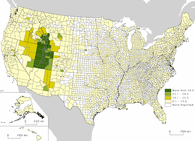
5 / Distribution of members of Mormon Church, by county, for the 50 United States.
Extra Credit / Indicates the known major fault zones in the 48 contiguous states.
1. Population Density
2. Average Annual Precipitation
3. X. The Louisiana Purchase, and Y. Yes, well, "Why?" really is the question, isn't it?
4. Topographic vegetation map of Tennessee.
5. Mormons? Mormon skiers?
Wait - extra credit? what's the extra credit? and isn't Tennessee shaped a lot like Pennsylvania?
1. Population
2. Hmmm. Average rainfall?
3. Oh boy. Get ready for the answers of a C-average student. How about the Louisiana Purchase and ummmm.... places to get cheap tequila?
4. basic to whom? Is it a map of ocean water temperatures?
5. green paint? No, how about Mormons?
1. pop density
2. rainfall
3. x - louisiana, y - gadsden
4. pennsylvania, but what kind? geological?
5. i was going to say indian reservations or national parks at first glance, but peering closely, it's clearly mormons.
1. Population Density
2. Raimfall
3. x= Louisiana Purchase
y = Gadsden Purchase (and yes, I just had my students shade in a similar map last week)
4. No clue
5. Mormons
Yo!
1. That's what we would call a map of population density, by county. Which is not quite the same thing as a map of population by county. Careful with that.
2. That's a map of annual precipitation. I grew up in the deep blue part.
3. Area X is the Louisiana Purchase. Area Y is the Gadsden Purchase.
4. That is a Geological Map of Pennsylvania.
5. And lastly, apparently not too challenging for a buncha sharp whippersnappers like yourselves, it's a map showing the proportion of Mormons among church members, by county.
...so it was Question 4, rather than Question 5, that was the butt-thumper this go-round. Geological maps (and plant hardiness maps, too -- a good guess from Elizabeth) have those crazy color schemes because they are expressing what they call "nominative data" in the biz. That means there's no sequence or quantity implied in the information, so you don't need or want a series of colors that implies "more" or "less."
Anyway.
When the dust settled o'er the maps, it's Chance and Mrs.5000 who ended up holding the Exclaimation Points. Mrs.5000 tightens her headlock on the MQ with seven (7) Exclamation Points; Chance moves into a tie (with Becky) for second, with four (4).
@Critical Bill: It took me three reads before I realized you were not calling it a "Topographic-Bum map of Egypt."
@fingers: I do love a pretty map of colors....
@d: The land taken by the U.S. after the Mexican War is an amazingly large chunk. Take a look at the southern border of Oregon and Idaho; before the war, that was the northern border of Mexico.
@Sandy: Up the Wolves! Up the Wolves!
(Inside joke. Sorry.)
@Rebel: Believe it or not, there wasn't any bloodshed with the Gadsden Purchase, just some duplicitous financial dealings. The U.S., after taking all of California, Nevada, Utah, western Colorado, and northern Arizona and New Mexico after the Mexican War, decided a decade later that it needed another little chunk for a good railroad route. And, Bob's your uncle!
@Bridget: Karmasartre was being characteristically puckish about the extra credit. Tennessee is shaped somewhat like Pennsylvania, but it's longer, pointier in the northeast, and missing the "Erie Panhandle."
@Kate: Mmmm.... Cheap tequilla.....
@Chuck: You should print out the quiz, and see how your students do! (Don't give them the blog URL, though, because every once in a while I say "fuck.")
i forgot again for the bajillionth time. i need to add the M5K quiz to my calendar. it's work related, right? sharpening my ever dulling brain?
just for the record, of course i know that mexico used to include california, et al. i just meant that maybe that was a late addition or something that had been renegotiated or something. i mean, i definitely got an inferior public education, but it wasn't that bad.
Can't believe I missed this one, dammit! I coulda been a contender...
Post a Comment