
Thematic Maps
2. What pattern does this map from late 2008 show?
1. What demographic pattern does this map show?
2. What pattern does this map from late 2008 show?
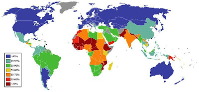
3. What social statistic is mapped here?
"Map out" your answers, if you will, in the comments.
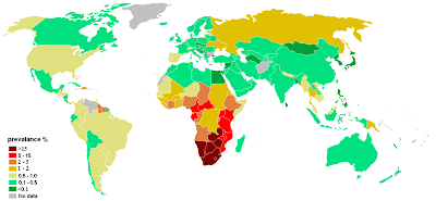
4. What does this map show the "prevalance" of?
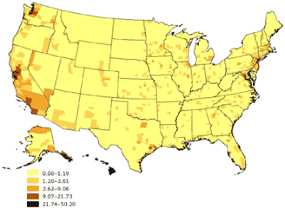
5. What demographic pattern is shown here?
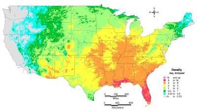
Extra Bonus Question: What does this map show the "Density" of? This is a very esoteric one, so if anybody gets it I'll be regarding them with a great deal of awe.
"Map out" your answers, if you will, in the comments.

21 comments:
I thought you said the Monday quiz was going to be on landmarks of Thailand. You big liar! =P
1. population density
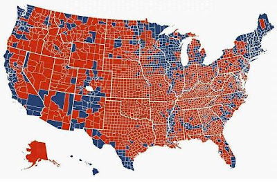
2. presidential election results by county
3. per capita wealth
4. diamond mines
5. AIDS infection rates
bonus: lizards
1. population density
2. presidential election results by county
3. literacy rates
4. HIV infection rates
5. College educated people
Bonus: Density of retired Midwesterners
1 population density
2 presidential voting by county
3 literacy rates?
4 hiv infections? that might be too obvious.
5 high numbers of single people under the age of 35
bonus number of french creole speakers
1. People who are really hot v. people who are scared.
2. R/D voting by county.
3. People over 4 feet tall.
4. HIV infection.
5. I think it has something to do with money.
6. I think it has something to do with topsoil.
No awe for me, baby!
I'm baa-aack...but no wiser.
1. Population density?
2. Voting Dem or Republican by counties?
3. Countries with English spoken (either as first or 2nd language)? Or maybe it's a high rate of unmarried mothers........
4. Manners? Anytime Canada shows up, I think of good manners....
5. Wealth?
Bonus: I was going to say "old folks" but that was unkind...can't be fire ants.... so I will guess early marriage age...skin cancer...golf courses... clearly I have no clue!
With the decathlon coming up, I figure I better start training, since I'm somewhat out of quiz shape. I wish I could just answer "density" for them all.
1. Population density.
2. County-level voting in presidential election.
3. "Social" had me pondering the difference between social and other types of statistics for far too long. I'm going with access to adequate housing.
4. AIDS.
5. Not population density, so, um, density of retirees in the population?
Oh, I messed up and left out #5 and now I've seen everyone else's answers. Shoot, I guess this is why I need to train.
1. Rain.
2. Mmmm... voting intention?
3. Literacy.
4. That could be the prevalence of AIDS. Or not.
5. Population (per sq mile, for example)
6. Hurricanes?
1 population density
2 blue Democrat/red Republican. I'm guessing it's the presidential vote by county, though it seems redder than I would have expected. It's the kind of map that always makes me glad votes aren't awarded one per square mile.
3 literacy
4 I'm guessing HIV infection rates
5 I'm guessing Asian-American population
6 I'm guessing outbreak of the West Nile virus
1. Population?
2. No WAY did Milwaukee go red and the rest of Wisconsin go blue, but I have no other idea for this one, so voting results? If that is what it is, than Wisconsin at least is wrong on this particular picture.
3. Literacy
4. HIV Infection Rates
5. Alaska Native/American Indian/Pacific Islander populations. Sure, lump them all together. They're all pretty much the same, right?
Bonus: Crap, some type of outbreak? Locust? West Nile? Lyme ticks? No, lyme disease is way more active in Virginia. And I never saw a locust once in the midwest. Is bird flu happening yet? That will probably come down from Alaska anyway... I'll go with West Nile. But I think that's hit the West coast now, but I can't think of anything else...
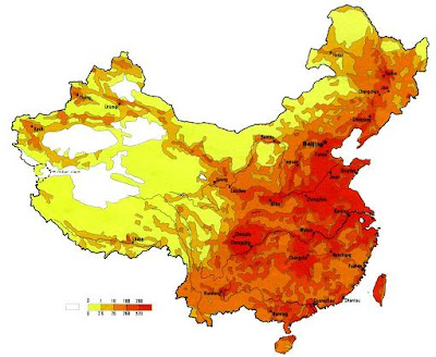
1. Population density in China
2. Republican (red) vs. Democrat (blue) counties in the Presidential election.
3. percentage of population that has a television?
4. AIDS?
5. percentage of Asian-Americans?
Bonus: ?? one thing they have a lot of down south, not so much in California, is Kudzu. I have no idea, really.
1 / Population density of China, exclusive of those terra cotta statues.
2 / Results in the 2008 presidential election by county where blue represents democrats and red =s republicans. Alaska is not depicted at the same scale as the other states, which is why, I assume, I cannot make out the county lines. Or maybe she has gotten rid of them.
3 / Greenland, Iraq, Somalia, Afghanistan, and Serbia (?) (and perhaps others) appear grey, which is not explained in the legend. What don't they have (socially)? Afternoon tea? I guess Life Expectancy.
4 / Reported cases of AIDS by country.
5 / Very tough. Percent of # reported deaths per capita of people using a recipe form the M5000 kitchen? Percent of people by county who like Crab Cakes? Number of pleasure craft per capita? Wine consumption? I'll guess People of Asian/Pacific Origin.
EBQ / Density of Southern Baptist churches across the lower 48.
1. I wish I could see the numbers on the key, but that would probably make it too easy for most of your readers. But it might explain why there seem to be two sets of numbers... Anyway, it looks like China, and I'll guess that the map is measuring population somehow.
2. Presidential election reports by county (blue=Democrat). That's a lot of Red. What's the one white county?
3. Percent of... vaccinations against smallpox.
4. HIV cases?
5. Native American population?
Bonus: sq. km per year of new parking lots.
1. That would be the population density of China.
2. That would be the county breakdown of the popular vote in the late presidential election.
3. That would be literacy rates.
4. That would be HIV infection rates.
5. That would be the density of Asian-Americans (giveaway: Hawaii).
Bonus: That, my friends, is a map of lightning strikes per km2/year. Mostly, I just wanted an excuse to put it in the blog.
Mrs.5000 makes life difficult for many of you by getting all of the answers right. If that's kind of infuriating, just think of what it's like to live with her.
Kadonk hits 4 1/2 to take the other MQLXIX EP.
How can an answer to #1 be correct without mentioning China? Etc.
@Reb: You didn't, like, believe me, did you?
@Sandy: If somebody compliments you for saying something really knowledgeable, you can say "well, I've been working out..."
@MJ: Not a bad guess for #1. Population and rainfall are often correlated...
@Kadonk: Without looking into the Wisconsin situation, a lot of time what happens is that the actual city will be in a very small county that doesn't show up well on a national map -- it will be a core of day-glo blue. But it will be surrounded by just-barely-red burbs, which are in much larger (area-wise) counties.
For number five, you got thrown by statistical noise up in the buroughs. If Native Americans were included, you'd see a lot more action in Arizona and S.Dakota and Oklahoma and such.
@Karma: I think what Iraq, Somalia, Afghanistan, & Western Sahara have in common is a consensus that no one really knows what the hell is going on there. What you are seeing as Serbia is, I think, just knots of international borders where the countries are very small. For Greenland, I'm starting to see it greyed out a lot on thematic maps; this might be a consensus that it packs a crazy amount of visual weight for its few tens of thousands of people.
Life expectancy was a reasonable guess, but doesn't match the tiny, hard-to-read legend....
@Ben: That's a lot of red, but a lot of it in rural counties without a ton of people in 'em. I believe the white county was a tie.
@Karma: You know, I too felt it was pretty sloppy not to mention China. Etc. But what can you tell these kids? What with all their "texting" and their "twittering" and their "crystal meth," its amazing you can get them to sit down and take a voluntary quiz of general knowledge at all. Standards just aren't what they were when you and I were young. Etc.
Dammit! Leave it to me to forget to check the quiz on "Thematic Map Day"!
Post a Comment